The Lincoln HighwayWhile hiking in the parklands on cliffs to the west of the Golden Gate Bridge several years ago, about five miles from our house, we came across this curious monument:
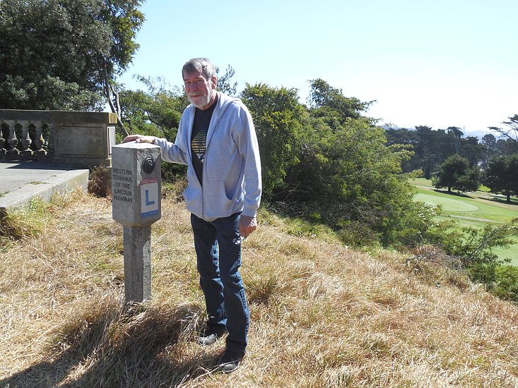 What is this, the "Lincoln Highway"? "Western Terminus?" This sounds like something really big! Bill remembered a road with that name from a summer he spent in Chicago Heights, Illinois, in the late 1950's. Somehow, then, the road felt like something more grand than a roadway connecting far south suburbs together. "Could this be the same road, he thought?" We did some research, and indeed this was the same Lincoln Highway. We learned that, back before highways had numbers like "Route 66", they had names. The Lincoln Highway was the first transcontinental paved road in the United States. Unlike Route 66, which many people travel and which is substantially paved over with interstates, we learned that much of the Lincoln Highway is still intact, a two lane road that goes through towns instead of around them, a highway that slows you down through towns to take in the view. As an idea coalesced in early 2013 to take a transcontinental road trip, we decided, "Let's do it on the Lincoln Highway!" The Lincoln Highway dates to 1913. In 1913, most American paved roads were in town, and they were paved by local governments. Outlying roads were seen primarily as a way to get people to town. Serious long distance travel was all done on the railroad. There was little interest in roadways at the state government level, and some states did not even have a state highway department yet. Early auto enthusiasts began to yearn for roads that would make long distance travel by auto to be feasible. The ultimate dream would be to have a paved road that crossed the country. Implementing it was undertaken at the local level, because that is how all roads got built then. A route was laid out that connected San Francisco and New York. Towns along the way were rallied to undertake construction of the road in their own areas. Several one mile sections were laid. These were called "seedling miles". The aim was that, by paving a few miles, this would encourage others to lay three thousand more. This seems ludicrous when one first reads of it, but in the case of the Lincoln Highway, it worked. Towns all along the way got busy and paved the road where it passed through. The highway that came out of this process lacked the uniformity you see in highways today, because it was built by so many different people. Concrete pavement was just coming into vogue, but brick pavement was also popular. When Bill was a kid in Southern Illinois, his family lived on a brick street. He can still remember the pleasant rumble of tires when a car would go by. His uncles told about the laying of the bricks when they were children. The "paving bricks" were denser and twice as thick as regular bricks that are used in buildings. This meant they were very heavy. Bill's uncles told of work crews that would be brought in from out of town. "The men had arms the size of legs," they said. They would lay bricks with both hands, as fast as they could move their arms. Brick streets were being laid all over America at this time, mostly in town because that was where paving was being done. However, some of them found their way in rural areas into the Lincoln Highway. The most unusual roads of the Lincoln Highway to find are brick ones out in the country, but other local curiosities brought to the construction of America's first ocean-to-ocean highway can be found all along its length. A constant stream of them will unfold as you join us on our journey. It is not possible to follow the Lincoln Highway exactly. In our first few miles we had to face the fact that the Lincoln Highway left San Francisco on a ferry that no longer runs. The Bay Bridge, not existing in 1913, had to be our substitute. There are places the highway has been rerouted, as is the case with any long road that is a hundred years old. Original routings can go through what is now private property. A stretch in Utah now goes through a nuclear test range. No, we did not want to go that way, and the military would not have let us anyway. Other stretches are passable gravel roads out in the desert with no cell service, and one could break down there and no one would come by in three days. Those sections had nothing to view but sagebrush, and there was no infrastructure concerning the road, nor old cool buildings to check out. A trip along the Lincoln Highway, after all, is significantly one about seeing infrastructure, as well as seeing scenery and meeting people. Therefore, in some places we took the way people go now to get around those problematical areas. We took the nearby paved road. Worth mentioning is this description of a stretch of the highway in Nevada which we opted to miss by taking a 15 minute trip on a nearby U.S. highway. The description comes from a routing of the highway shown on Google:
 Having a guide to follow the route is essential on a quest such as this. Markings of the route vary from state to state, and this variance is from "quite good" to "non-existent". Part of the fun on the trip was finding the variety of markings that the many localities had put up. One town painted their fire hydrants in the highway's colors. Look for that one! If you decide to drive the highway yourself, guidebooks, maps, and other information are readily findable on Google. Each author of such you will find has a certain primary interest. One guide we found was primarily about places to eat along the way. It even told us that one of the author's favorite places to eat was no longer there, but they had built a Walmart on the site and the Walmart served food. We cracked up. The Google map, just mentioned, was heavily slanted towards infrastructure. If you are interested in pillars in the weeds of long-ago-collapsed bridges, this is the guide for you. And many of the guides are intended to get you to spend as much time and money at the shops of whoever printed them. You need the guides, but take each of them with a grain of salt. One comment we would make is, although you can find stuff on the Internet, take written notes from it or print it out. Most of the highway is in rural areas where Internet data connections are extremely slow if not non-existent. Even in some motels you will not find the bandwidth to enjoy sites with images, and this is not likely the motel's fault. Some of the towns just don't have high speed Internet available anywhere in the town. As you look at our photos, you will see lots of old buildings. All dying off-the-beaten-path towns have old buildings. Special, though, are the ones that clearly catered to the hordes that traveled the Lincoln Highway in its heyday, and the ones that carry the Lincoln name. Let these take you back in time, and let the roadway reveal to you the pace and scenery one enjoyed in travel in a time long ago. We are old enough to remember before there were interstates, and the roadway as it is today is authentic enough for nostalgia to run deep. In one way, the highway gives one an experience that is more relaxing and peaceful than we remember as children. There are almost no trucks on the Lincoln Highway. They are all over on the interstate! Another thing you must want to notice is how the landscape changes as you cross the continent with us. The variety as one crosses America on a 3000 mile long highway is immense. We have much to show and much more to tell, but we won't present it here on this page. Join us as our trip unfolds, on the Lincoln Highway!
(Begin this slide show.)
[ Bill & Larry's Adventures ] |